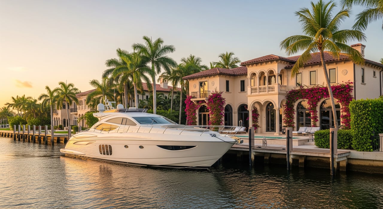
If you are shopping for a Boca Raton waterfront home and you own a boat, three questions matter most: How much water is under the dock, what bridges are on your route, and how quickly can you reach the ocean. The answers vary block by block, even within the same neighborhood. In this guide, you will see Boca’s most boater‑friendly areas and a clear checklist to pre‑screen listings against your vessel’s size and draft. You will also learn how to verify key details before you tour. Let’s dive in.
How to choose the right waterfront for your boat
Before you fall in love with the view, match the property to your boat. Use these factors to filter homes efficiently.
- Canal width and turning basin. Narrow canals suit smaller center consoles, while wider canals and basins are more comfortable for larger express cruisers and sportfish boats. Record the distance from seawall to opposite bulkhead and note where you can turn.
- Water depth at mean low water. Depth alongside the dock and in the canal determines safe draft and whether dredging might be needed. Ask for recent soundings and plan a marine surveyor depth check before removing contingencies.
- Bridges and vertical clearance. Count the bridges between the property and the ocean. Note if they are fixed or draw, and confirm published vertical clearances and any opening schedules. Always confirm whether heights are listed at mean high water or mean low water.
- Distance and time to the inlet. Offshore owners often prefer shorter runs with fewer bridge openings. Estimate minutes underway using chart distances and your typical cruising speed, then verify in the field.
- Dockage and permitting. Actual usable dock length depends on permits, piling layout, setbacks, and any HOA or municipal rules. Pull dock permits and look for limits on vessel length or number of boats.
- Seawall condition. A tired seawall can mean large future costs. Capture photos and request a seawall inspection as part of your due diligence.
- Nearby service infrastructure. Note the closest full‑service marinas, haulout options, mechanics, and fuel. This becomes more important as vessel size increases.
Boca Raton areas to shortlist for boaters
The neighborhoods below are popular with boat owners. Conditions vary house to house, so use the verification steps that follow before you tour.
Royal Palm Yacht & Country Club (East Boca)
Why boaters like it. You will find established waterfront estates with private docks, direct access to the Intracoastal Waterway, and a yachting culture supported by nearby marina services.
Typical vessel fit. Many properties support larger express cruisers and sportfish boats, with deepwater docks and on‑dock power common. Actual capacity depends on the specific dock permit and canal geometry.
What to verify. Confirm permitted dock length, piling layout, and any HOA or club rules that cap vessel size. Record depth off the dock at mean low water and capture seawall condition.
Nearby services. Full‑service marinas and contracted service providers are a short run away, which simplifies fueling, maintenance, and provisioning.
Top cautions. Dock permits can limit length overall even when the waterfront appears long. Canal widths and turning options vary; confirm your turning plan if your boat is longer or has a wide beam.
Buyer action items. Pull the recorded dock permit, check charted depths, and log bridge count and types on your preferred route to the ocean.
Boca Raton Municipal Marina / Downtown Boca
Why boaters like it. If you want a downtown lifestyle with reliable docking, the municipal marina area offers centralized slip options, fuel access, and quick provisioning.
Typical vessel fit. Transient slips can handle a range of boat sizes. Your fit depends on slip availability, maximum length overall, and service capacity at nearby yards.
What to verify. Check slip availability and waiting lists, as popular marinas can be at capacity. Confirm maximum permitted vessel length for the slip you want and the local travelift capacity if you expect to haul out nearby.
Nearby services. You can access fuel, haulout arrangements, and marine trades without long transits, which keeps maintenance efficient.
Top cautions. Slip policies change and seasonal demand can spike. Always verify terms, insurance requirements, and any limitations on liveaboard or commercial activity.
Buyer action items. If you plan to rely on a slip rather than a private dock, start the marina application process early and verify bridge clearances on your route.
South Boca: Red Reef Park and South Beach Park area
Why boaters like it. Homes in South Boca enjoy quick access to the Intracoastal and a short run to nearby inlets for ocean days.
Typical vessel fit. Sections with wider canals work well for mid‑size center consoles and many cruisers. As always, individual canal and basin widths matter.
What to verify. Confirm channel width and depth from the property to the Intracoastal. Note any bridges on the route and whether they are fixed or draw.
Nearby services. You will find fuel and service support within a short run, which makes day trips and regular upkeep straightforward.
Top cautions. Shoaling and seasonal water level changes can influence depth at low tide. Monitor local notices for any dredging or bridge work.
Buyer action items. Record canal width across from the seawall, check charted depths at mean low water, and verify bridge heights using official sources before scheduling showings.
North of Spanish River: canal neighborhoods
Why boaters like it. The waterways north of Spanish River include residential canals with private docks, and some areas have wider basins that simplify maneuvering.
Typical vessel fit. Many canals accommodate mid‑size cruisers and larger center consoles, with select spots suited to bigger vessels where turning room is generous.
What to verify. Measure basin width, evaluate turning radii near your potential dock, and ask about any recorded dredging or maintenance history.
Nearby services. You can reach multiple marinas and service providers within a practical run, which helps if you plan regular offshore trips.
Top cautions. Canal characteristics change parcel by parcel. Depth at the seawall can differ from the charted channel, so plan a site‑specific depth check.
Buyer action items. Pull property and dock permits through city and county records, then map the bridge count and route to your preferred inlet.
ICW islands and small peninsulas
Why boaters like it. Many parcels front the Intracoastal directly and were developed with private boating in mind. Select properties were intended for larger vessels.
Typical vessel fit. Where permitted and properly configured, you may find longer dock setups suitable for larger boats. Make sure the frontage truly faces the Intracoastal rather than a narrower canal.
What to verify. Confirm whether the lot fronts the ICW or an internal canal, the maximum permitted length overall for the dock, and the number of fixed or drawbridges on your route.
Nearby services. Direct ICW frontage often means quick access to fuel and service options up and down the waterway.
Top cautions. Exposure to wake can vary with location on the Intracoastal. Balance convenience with comfort by noting fetch and typical traffic in front of the property.
Buyer action items. Verify permits, power pedestal specifications, and piling layout. Plan your turning approach and confirm depths at mean low water alongside the seawall.
What to verify before showings
Use this quick checklist to save time and avoid non‑starters.
- Waterfront footage from county records and visible dock length and configuration
- Dock equipment: lift size and condition, cleats and pilings, 30 or 50 amp power, and water
- Seawall condition: visible wear, patches, or scouring
- Canal geometry: width across from the seawall and where you will turn
- Bridge inventory: count, type, and published clearances on the route to the ocean
- Charted depths at the dock and in the channel at mean low water
- Dock permits: maximum permitted vessel length and any HOA or deed restrictions
- Notices about dredging or shoaling that could affect your access
- Nearby marina services, including haulout capacity and fuel options
How to get the numbers you need
Turn your shortlist into confident showings using official sources.
- Nautical charts. NOAA electronic and raster charts show channels and soundings. Commercial chart apps help estimate routes and time underway, but confirm details with official charts.
- Bridge data. The U.S. Coast Guard publishes vertical clearances and opening procedures. Always confirm whether heights are listed at mean high water or mean low water.
- City and county records. Palm Beach County GIS and City of Boca Raton permitting records can show dock dimensions, seawall permits, and waterfront footage. These records help confirm what is allowed, not just what is built.
- Inlet and channel maintenance. The U.S. Army Corps of Engineers posts dredging projects and channel updates that affect depth and access.
- Environmental permitting. Florida Department of Environmental Protection and the South Florida Water Management District regulate certain coastal construction and setbacks.
- Local knowledge. Marinas and yard operators can share slip availability, travelift capacity, and practical tips on shoaling and bridge delays. Treat anecdotes as helpful, then cross‑check with official notices.
Quick rules of thumb
Use these starting points, then verify with measurements and permits.
- If any fixed bridge on your route has less clearance than your air draft, your boat cannot pass without an opening, or at all if the bridge does not open.
- If depth at mean low water alongside the dock is less than your vessel’s draft plus a safety margin, you will need dredging or a different property.
- Narrow canals without a turning basin make docking a boat longer than roughly three‑quarters of the canal width challenging. Favor wider basins for larger boats.
- Dock permits often cap length overall. A long physical dock does not guarantee space for a larger vessel if the permit says otherwise.
Work with a local, boat‑savvy team
When a property must fit your boat, precision matters. The most efficient way to shop is to pre‑screen listings against your vessel’s length, beam, draft, and air draft, then verify canal geometry, depth, bridge clearances, and dock permits before you tour. For any home that passes those desktop checks, schedule a marine surveyor for a depth sounding and seawall inspection as a contingency.
If you want a focused, concierge search through Boca’s waterfront, connect with a team that lives this market and understands the details that matter to boaters. Reach out to Vlasek Real Estate Group to Request Your Personalized Consultation. We will help you translate your boating needs into a targeted shortlist, coordinate the right verifications, and negotiate with confidence.
FAQs
How do I check water depth at a Boca Raton dock before I make an offer?
- Ask for recent soundings, then plan an escrow‑contingent marine surveyor depth check at mean low water before removing contingencies.
Where can I find official bridge clearances on routes from Boca Raton neighborhoods to the ocean?
- The U.S. Coast Guard publishes bridge clearances and opening procedures; confirm whether heights are listed at mean high water or mean low water.
Will an HOA or the city limit the size of the boat I can keep at a Boca Raton home?
- Many HOAs and municipal codes cap dock size or number of boats; always review deed and HOA documents plus dock permits for specific limits.
How close is close enough to the inlet for frequent offshore trips?
- Serious offshore anglers often target 10 to 20 minute runs, while many cruisers are comfortable with 20 to 45 minutes, but verify using charts and trial runs.
Does a long‑looking dock mean I can berth a 60‑foot boat at that property?
- Not necessarily; usable length depends on permits, piling layout, setbacks, and clearance to neighboring seawalls, so verify recorded permits and as‑built dimensions.